
May 24, 2022
Take Me to the (Farmington) River
Armed with a sizable student packet and an abundance of intellectual curiosity, the entire Form 3 class headed to Farmington River Park in Bloomfield for some hands-on, feet-wet expeditionary learning.
Originally the estate of Joan Adams Davis, the 78-acre park was purchased by Bloomfield in 1995 and converted into a public park. The students were charged with evaluating the decision of the town to purchase these land parcels for acquisition and conservation by land trusts.
The brainchild of Upper School science teachers Graham Hegeman, Carmen Kreager, and Alexa Tzanova, the class trip was organized into four workstations throughout the park headed by a faculty member: land evaluation. river/stream/pond, glacial history and soil, and biodiversity.
The student packet contained a series of prompts at each station, asking the students to consider their surroundings. For the first station (property walkthrough), the students were use their senses to observe the conditions of the soil, the presence of wildlife, and their orientation on the map. Working in small groups, the students huddled together pointing at trees and avoiding treacherous patches of poison ivy. The students were tasked to evaluate the land based on a rubric of size, slope, natural resources, and undeveloped space among other criteria.
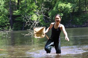
Students headed into the water to collect minnows and other aquatic invertebrates at Station 2, located on the shores of the Farmington River. Using nets and leaf skimmers, some intrepid students donned waders and collected samples of fish and water. The groups analyzed the quality of the water with their API water test kits for pH, nitrites, and ammonia.
The student packet explained the prehistoric creatures of the surrounding land at Station 3. After the glaciers melted, a tremendous lake, Lake Hitcock, was formed that covered most of New England. Approximately 12,000 years ago, the lake breached its dam forming the Connecticut River and its tributaries. Observing the rocks and sediments around them, the students found evidence of the presence of glaciers i.e. boulders that were deposited by glaciers. Using sieves, the students analyzed the soil to determine its content of gravel, sand, silt, and clay.
Lastly, the students measured the diameter of some of the park’s trees and assess the prevalence of invasive wild garlic mustard in station 4.